Ocean Intelligence

A FORECAST MAP FOR OCEAN PLASTICS

SeaNet detects macroplastics in near-real time,
predicts their drift like a weather system,
and reveals evolving hotspots on an interactive, radar-style map.

Mission

TURN OCEAN DATA INTO ACTION

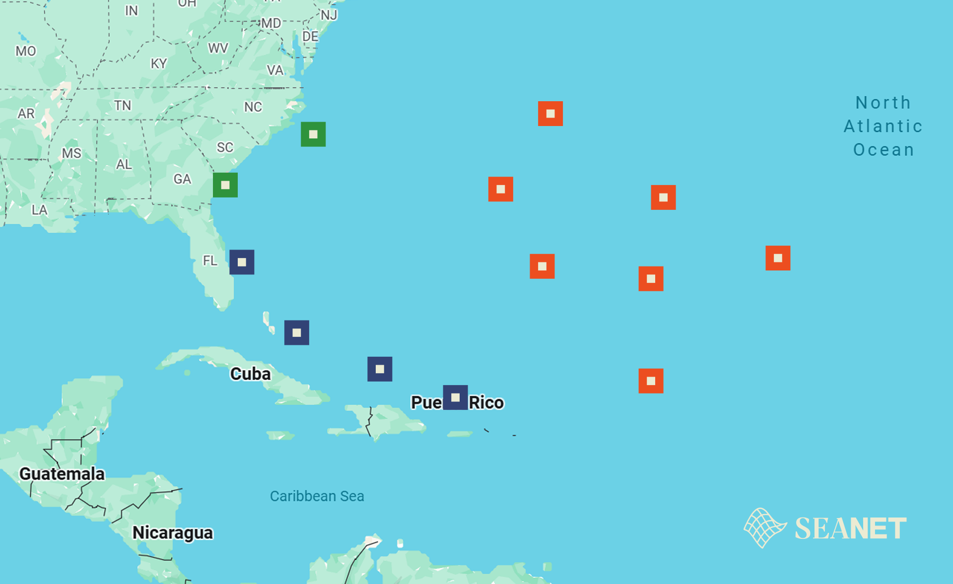
We translate satellite cues and ocean models into daily, practical guidance for cleanup teams, coastal managers, NGOs, and policymakers. SeaNet makes plastic movement visible, predictable, and actionable.

  • Detect macroplastic patches from Sentinel-2 cues.
  • Forecast drift with particle trajectories and met-ocean forcing.
  • Act using hotspot areas, risk thresholds, and confidence.
At a glance

Key Numbers

0
hrs forecast horizon
0
oceans targeted
0
data sources
0
% uptime goal

Figures are MVP targets; subject to validation and region.

Live Map

HOTSPOTS, CONFIDENCE & DRIFT LINES

Explore a radar-like view of evolving plastic hotspots with overlays for currents, wind, and model confidence. Time-scrub from now to +5 days.

Technology

HOW SEANET WORKS

SeaNet combines satellite imagery, ocean models, and machine learning into one scalable platform for tracking objects at sea. The system processes Sentinel-2 data to detect targets, seeds particle-drift simulations with real-time met-ocean forcing, and delivers short-term trajectory forecasts on an interactive radar-style map.

Pipeline

From Detection to Action

1. Detect

Sentinel-2 imagery → spectral indices → target identification.

2. Validate

Cross-reference with known data → confirmed locations.

3. Forecast

Particle drift models driven by currents & wind.

4. Deliver

Interactive map with areas, trajectories & confidence.

Abstract ocean currents
Impact

FROM SIGNAL TO STRATEGY

By turning hidden threats into visible data, our real-time tracking empowers scientists, cleanup teams, logistics operators, and communities to act where it matters most — protecting marine life and unlocking commercial value from ocean intelligence.

Coastline
Author: Francis Perez
Ghosts into Warnings — Ghost Nets

Up to 10% of marine litter comes from lost fishing gear, which entangles and kills around 640,000 marine animals every year. Our real-time tracking database shows exactly where nets are drifting, helping cleanup teams act fast and save lives.

Open sea
Uncovering the Everyday Flood — Plastic Bottles

More than 1 million plastic bottles are sold every minute, many ending up in rivers and oceans. We map hotspots so cleanup teams can act fast, making removals quicker and more efficient.

Beach view
Wrappers: Small Pieces, Big Consequences

Wrappers rank among the top 10 coastal plastics and are often fatal when seabirds and turtles mistake them for food. Our system highlights where they cluster, saving scientists hours of searching. Removing just 10,000 wrappers could spare hundreds of seabirds from starvation.

Commercial Use

BEYOND PLASTICS — OCEAN LOGISTICS

The same satellite detection and drift-forecasting engine that tracks plastic pollution can be applied to commercial maritime challenges — from lost cargo to fleet optimization.

Container & Cargo Localization

Every year an estimated 1,000+ shipping containers are lost at sea. SeaNet's drift prediction models can locate and forecast the trajectory of lost containers, reducing recovery time and costs for insurers and shipping lines.

Maritime Asset Tracking

Ports, offshore operators, and aquaculture farms can use SeaNet to monitor floating assets and infrastructure in near-real time — reducing losses and improving operational planning through satellite-based awareness.

Risk Assessment & Insurance

Insurers and coastal planners can leverage SeaNet's hotspot data and drift forecasts to quantify marine debris risk, optimize policy pricing, and support evidence-based damage prevention strategies.

Validation & Partners

Built with & for the ocean community.

Blue-Cloud logo EDITO logo Copernicus logo Google Earth Engine logo ESA logo
Video

WATCH THE SEANET OVERVIEW

Whitepaper

Dive deeper into the method

A short PDF outlining indices, validation strategy, and drift model settings. Versioned for reproducibility.

Download
Team

PEOPLE BEHIND SEANET

A compact team blending ocean science, remote sensing, and product design.

Member
Samuel Jancík
CEO
Member
Kristýna Říhová
Chief Scientific Officer
Member
Albert Schwanzer
CTO
Member
Michal Branda
IT Development
Member
David Nohejl
IT Development
Member
Eduard Červinka
IT Development